

You can find on this page the Washington DC topographic map to print and to download in PDF. The Washington DC elevation map present the topography, river and relief of Washington DC in USA.
The Washington DC topographic map shows elevation, hills and landforms in Washington DC. This elevation map of Washington DC will allow you to know topography, river and relief of Washington DC in USA. The Washington DC topographic map is downloadable in PDF, printable and free.
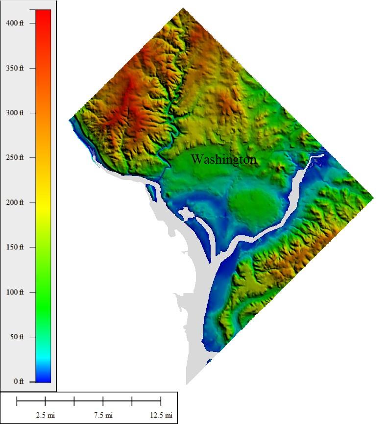
The highest natural elevation in Washington DC is 409 feet (125 m) above sea level at Fort Reno Park in northwest Washington as you can see in Washington DC elevation map. The highpoint was resurveyed and a new USGS Benchmark was placed in 2007 at coordinates N 38.95198 and W 77.075922, a location open to the general public and outside the fenced area where the highpoint was previously believed to be. Fort Reno, is actually lower than the top of the Washington DC Monument, which rises 555 feet from nearly sea level.
The lowest elevation point in Washington DC is sea level at the Potomac River as its shown in Washington DC elevation map. The deepest point near Morgantown, Md., in the tidal portion of the river below Wash- ington, Washington DC, is 107 feet. A navigable channel depth of 24 feet is maintained for 108 miles in the tidal portion of the river, downstream from Washington DC.
Washington DC is relatively flat and located at 410 feet above sea level at its highest point and at sea level at its lowest point as its mentioned in Washington DC elevation map. The elevation of Washington DC varies all around the city, with the lowest point being at 0 feet (0 m) in the waters of the Potomac River, and the highest elevation point being at 409 feet (125 m) above sea level at Fort Reno Park, located in the Tenleytown neighborhood in the northwest section of the district. The average elevation of Washington DC is 150 feet (50 m).